The Author – Bart Busschots
Creative Commons
Unless otherwise stated, the content on this site is licensed under Creative Commons Attribution, Noncommercial, No Derivative Works 3.0 License


Oct
1
WW1 – Antwerp in 1914
Filed Under History & Geography on October 1, 2014 | 2 Comments

“Zeppelin bombing Antwerpen” by Ad Meskens – Own work. Licensed under Public domain via Wikimedia Commons.
One hundred years ago today, the siege of Antwerp was underway. It started on the 29th of September 1914, and the city did not capitulate until the 10th of October. Rather than re-tell the story of the siege, which you can read in so many places, I thought I’d share a Google Earth map I’ve spent the last six weeks creating showing the core infrastructure of the Antwerp area as it was in 1914. When reading about large-scale historical events, I like to use Google Earth to follow along with what I’m reading and get a sense of the local geography. The thing is, if you do that with the siege of Antwerp you may find it confusing to follow along because there have been some very significant changes in and around the city in the last 100 years.
In this post I’m going to detail some of the very big changes, but really, for the best experience, you want to download the KMZ file and explore it at your leisure in Google Earth. I’ve also included a substantial area to the west of the city in the map, as far as Ghent in fact, because this is the route along which the Belgian army successfully withdrew from the city as the siege neared its end.
The KMZ File
The KMZ file is broken into two primary sub-folders, one for outlines, and one for labels. The reason for this is that having the labels displayed while zoomed out makes the map too cluttered to get a good overview, so you can check both on or off independently.
On the map, military fortifications that were active in 1914 are shown in red, military inundations in purple, and large recently decommissioned (in 1914) military fortifications are shows in orange. Navigable waterways, be they rivers, canalised rivers, canals, or maritime canals, are shown in blue. Docks which existed in 1914 are shown by blue overlays, and any docks not overlaid did not exist in 1914. Railway lines that were active in 1914 are shown in green, as are important railway stations. Large railway yards are shown as green overlays.
There are details available on all the shown items. For waterways and railways, click on the green or blue line to see the descriptions, for military fortifications, railway stations, locks, and docks, click on the icons.
For the best experience I recommend disabling all the standard layers except for Borders and Labels. The roads and photos in particularly are very distracting, so I definitely recommend turning those off.
Below are some links to various tellings of the story of the siege of Antwerp:
- The Wikipedia page describing the siege
- A short description of the siege on firstworldwar.com
- Arthur Conan Doyle’s description of the siege
- A description of the siege on metalfloss.com
Aug
24
WW1 – The Canals & Railways of Mons
Filed Under History & Geography on August 24, 2014 | 1 Comment
100 years ago today, the British Expeditionary Force (BEF) was involved in its first major engagement of the first world war – the Battle of Mons. The battle revolved around a canal that no longer exists today – the Canal Mons-Condé, a canal that does still exist (though it’s been upgraded significantly) – the Canal du Centre, and the medieval city of Mons near the Belgian-French border.
The British had been tasked with holding the line of the canal around and to the west of Mons, but the big problem for them was that in 1914, the route of the canals involved created a salient around the village of Nimy just north of the city. Looking at the canals that exist in Mons today there is no sign of a significant salient, you need to see the canals as they were in 1914 to understand this battle.
The reason there are many canals in this region is the presence of a big coal seam in the area to the west of Mons and to the south of the original Canal Mons-Condé. This area is known as the Borinage. The coal mines are all closed now, but the Borinage was a hive of industrial activity in 1914. I couldn’t find a good source of opening and closing dates of coal pits. If I had I would have mapped those that were open in 1914, but in the absence of that information I decided to map the railway lines as they existed in 1914. The tangle of lines to the south of the canals shows area that was involved in coal production very clearly. Note that I only mapped the mainline railways (NMBS/SNCB line numbers below 200), the nest of lines you see was surrounded by countless industrial lines and sidings.
Aside: While I wasn’t able to find a good list of pit opening and closing times, I did find a list of the locations of the spoil heaps created by the pits a few years ago, which I mapped and published in this blog post back in 2011.
The map above shows the canals in Mons as they were in 1914 in light blue, the railways as they were in 1914 in dark blue, and the canals as they are now in red. You can download the KML file to view the map in Google Earth.
Aug
22
WW1 – The Railways of Namur in 1914
Filed Under History & Geography on August 22, 2014 | 1 Comment
This post is a follow-on from yesterday’s describing the ring of fortifications around Namur, and the siege that was taking place there 100 years ago today. Along with Liège, Namur is one of just two fortified cities in the east of Belgium. Why were these two cities chosen for fortification? I would argue it’s either directly or indirectly because they’re important transport hubs. Indirectly because the reason both cities grew to be so important was because of their transport connections, initially via rivers, and later via road and rail. And directly because they were (and are) both major railway hubs. In 1914 there were no heavy-lift aircraft, so the way militaries moved large volumes of men and equipment rapidly was by rail.
The short version of why Namur was so important is that in 1914 it had railway connections to Aachen in Germany and Maastricht in the Netherlands via Liège, directly to Brussels, to Paris via Charleroi, to Luxembourg, to Givet in north-eastern France via Dinant, and to the coal-rich north-east of Flanders via Tienen.
The map above shows Namur’s railway infrastructure as it was in 1914 (you can download the KML file to view the map in Google Earth).
Aug
12
WW1 РThe Railways of Li̬ge in 1914
Filed Under History & Geography on August 12, 2014 | 1 Comment
The reason the Germans decided to violate Belgian neutrality was to give them access to France, and the reason Liège was their first major target was because that city’s railroads were a great way to quickly and efficiently move men and supplies from Germany into France. Today Liège is still an important railway city, with international trains calling at its magnificent new station. While much is still as it was in 1914, a lot has changed in the last 100 years all the same, enough that I thought it might be useful to create a Google Earth map showing what Liège’s railway infrastructure looked like in 1914.
Apr
26
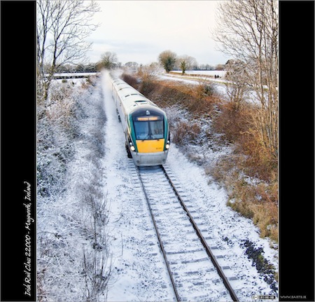
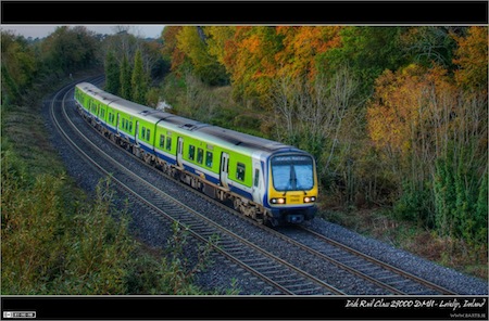
Photo of the Week 166 & 167 – Irish Rail Class 22000
Filed Under Photography on April 26, 2011 | 2 Comments
I was bold again last weekend so this is yet another double post to get caught up again. The theme for this post is the new(ish) Irish Rail Class 22000 InterCity trainsets. These modern looking diesel multiple units have now replaced more traditional locomotive-hauled trains on the majority of Ireland’s InterCity routes. As well as being quite fast (rated to 100 miles an hour in Ireland), they also have plugs at every table, and are both quiet and comfortable. A nice modern addition to the Irish Rail fleet, at least from a passenger point of view. The die-hard train spotters all hate them for not being locomotives of course, but change always comes hard to fanatics. Personally, I love to travel on them and I think they look good and are very photogenic, so put me down as a fan 🙂
This first shot was taken on a beautiful summer evening and shows No.22043 rounding a corner at about 80mph as it approaches Maynooth with an InterCity service from Sligo to Dublin. The unit was quite new when this shot was taken, but already one of the covers for its couplers was missing.
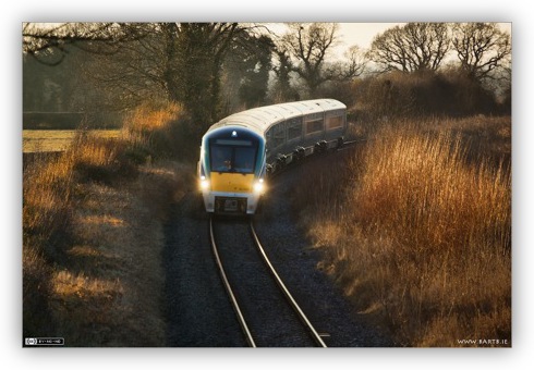
- Camera: Nikon D40
- Lens: Nikon DX AFS 55-200mm
- Exposure: 1/640 sec
- Focal Length: 165mm
- Focal Ratio: f/5.3
- ISO: 400
- Camera Mode: Full Manual
- Processing: tonemapped lightly with Topaz Adjust, then tweaked a little using the built-in Dodge & Burn plugin in Aperture 2
The second shot is a more recent one, taken on a lovely spring evening this February, and shows the same trainset, this time approaching Pike Bridge with an InterCity service from Dublin to Sligo.
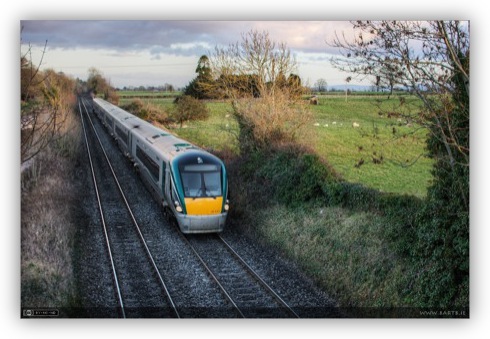
- Camera: Nikon D40
- Lens: Sigma EX 30mm f/1.4 DC HSM
- Exposure: 1/200 sec
- Focal Length: 30mm
- Focal Ratio: f/3.5
- ISO: 200
- Camera Mode: Full Manual
- Processing: created by tonemapping a single RAW image with Photomatix Pro, tweaking the result with the Topaz Adjust 4 plugin, and finally making a few small adjustments in Aperture 3
Jan
24
Pondering US -v- EU Locomotives
Filed Under 42 (Life the Universe & Everything) on January 24, 2011 | 11 Comments
This all started with a really childish and really stupid comment on Flickr by a young American rail fan:
Probably because the cabs on American locomotives aren’t ugly as the atrocious things that pass for locomotives in Europe.
The sheer childishness of it all put me off replying, but it did start me thinking, apart from the very obvious difference in style, what are the real differences between our locomotives?
Dec
15
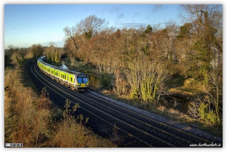
Photo of the Week 147 & 148 – Winter Trains
Filed Under Photography on December 15, 2010 | 2 Comments
Despite the fact that it’s been thawing for 5 days now, there is still an inch of ice on the street in front of my house, so I figured it might be appropriate to stick to a winter theme for this double post. I’m still ill, so none of these shots are from our recent cold snap, but instead, from the one before that, in January this year. Knowing my fascination with trains I’m sure no one will be surprised that I’ve picked two railway shots for this post.
The first shot I’ve chosen is of an Irish Rail Commuter train taken from Pike’s Bridge near Maynooth. This is a Class 29000 Diesel Multiple Unit (DMU), and it’s making it’s way from Dublin to Maynooth. The frozen water in the foreground is the Royal Canal.
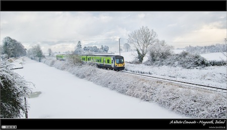
- Camera: Nikon D40
- Lens: Nikon DX AFS 18-55mm (D40 kit lens)
- Exposure: 1/160 sec
- Focal Length: 18mm
- Focal Ratio: f/8
- ISO: 200
- Camera Mode: Aperture Priority
- Exposure Bias: 1.0ev
- Processing: created by merging the original version of this shot with a version enhanced using the Topaz Adjust plugin
The second shot shows an Irish Rail InterCity service from Sligo to Dublin approaching Jackson’s Bridge near Maynooth. This is also a DMU, but this time of the newer and more comfortable Class 22000.
- Camera: Nikon D40
- Lens: Nikon DX AFS 18-55mm (D40 kit lens)
- Exposure: 1/320 sec
- Focal Length: 22mm
- Focal Ratio: f/3.8
- ISO: 200
- Camera Mode: Aperture Priority
- Exposure Bias: 0.67ev
- Processing: tweaked using the Topaz Adjust plugin
Nov
11
Photo of the Week 143 – Autumn Boat Train
Filed Under Photography on November 11, 2010 | 1 Comment
With this long-drawn out illness the past few months I’ve literally missed all the Autumn colour this year. So, since I got no new autumnal pictures this year, I thought I’d share of of my favourites from last year.
Here we see an evening train service from Maynooth to the port in Rosslare as it rounds the fairly sharp turn on the approach to the new Matt Goff Bridge just in Leixlip. This shot has been quite heavily tonemapped to bring out the best of the colours, I have a feeling some people may find the processing a little too extreme, but I like it, and since it’s my photo that’s all that matters 😉
For the train spotters among you, this is an Irish Rail Class 29000 railcar set, number 29018 to be precise. If you have good eyesight you can probably read the number on the front of the train which reads 29418, it will read 29118 on the other side, and the middle two carriages will have the numbers 29218 and 29318, hence the whole unit is referred to as 29018. These units come in blocks of 4, but can be joined together to make larger trains of 8 or even 12 carriages. The 29000s are very much the work horses for Irish Rail’s commuter and local services, though you do sometimes see them on longer national routes too. From a passenger comfort point of view, they’re fine for short services, but I’m not along in groaning when I see one pull up to the platform when I’m travelling InterCity.
- Camera: Nikon D40
- Lens: Nikon DX AFS 18-55mm (D40 kit lens)
- Exposure: 1/200 sec
- Focal Length: 30mm
- Focal Ratio: f/3.5
- ISO: 200
- Camera Mode: Full Manual
- Processing: created by tonemapping a single RAW image with Photomatix Pro, and then tweaking the resulting image with Aperture’s built-in Dodge & Burn plugin
Jul
6
Belgian Railway History Project – Update
Filed Under History & Geography on July 6, 2010 | Leave a Comment
I though today might be a good time to share another snapshot of my on-going project to Map all Belgium’s railways, past, present, and even to some extent future, with Google Earth. This snapshot is much more complete than the last one, though I still don’t consider it even close to finished.
Apr
4
Photo of the Week 111 – A Winter Evening Commute
Filed Under Photography on April 4, 2010 | Leave a Comment
I’ve taken shots of quite a few special trains recently, but somehow I still prefer this one, even if it is of just a plain ordinary commuter train. I really love this spot because it allows for a big sweeping composition which I really like. It helps give a nice sense of depth, and strangely also speed. I also really like the warm evening light which this shot was taken in.
The processing here is quite complicated. The first step was to take the original RAW image and tonemap it with Photomatix Pro. Secondly the RAW image was loaded into Aperture and tweaked to correct the exposure a little and to boost the colour a bit. This second version of the image was then exported to Photoshop Elements and the Topaz Adjust filter was applied to produce an alternative tonemapped version. The version from Topaz did a better job on the train and the trees in the background while the version from Photomatix was better for all the rest. This final image was generated by using Layer masks in Pixelmator to blend the two versions of the image into a third version with the best elements from each of the two other versions. This third blended version was then taken back into Aperture, given a few minor tweaks and then sent to the Dodge & Burn plugin in Aperture to do a few minor localised teaks.
- Camera: Nikon D40
- Lens: Nikon DX AFS 18-55mm (D40 kit lens)
- Exposure: 1/400 sec
- Focal Length: 26mm
- Focal Ratio: f/4
- ISO: 200
- Camera Mode: Full Manual
- Processing: see above.