The Author – Bart Busschots
Creative Commons
Unless otherwise stated, the content on this site is licensed under Creative Commons Attribution, Noncommercial, No Derivative Works 3.0 License


Oct
1
WW1 – Antwerp in 1914
Filed Under History & Geography on October 1, 2014 at 11:12 pm

“Zeppelin bombing Antwerpen” by Ad Meskens – Own work. Licensed under Public domain via Wikimedia Commons.
One hundred years ago today, the siege of Antwerp was underway. It started on the 29th of September 1914, and the city did not capitulate until the 10th of October. Rather than re-tell the story of the siege, which you can read in so many places, I thought I’d share a Google Earth map I’ve spent the last six weeks creating showing the core infrastructure of the Antwerp area as it was in 1914. When reading about large-scale historical events, I like to use Google Earth to follow along with what I’m reading and get a sense of the local geography. The thing is, if you do that with the siege of Antwerp you may find it confusing to follow along because there have been some very significant changes in and around the city in the last 100 years.
In this post I’m going to detail some of the very big changes, but really, for the best experience, you want to download the KMZ file and explore it at your leisure in Google Earth. I’ve also included a substantial area to the west of the city in the map, as far as Ghent in fact, because this is the route along which the Belgian army successfully withdrew from the city as the siege neared its end.
The KMZ File
The KMZ file is broken into two primary sub-folders, one for outlines, and one for labels. The reason for this is that having the labels displayed while zoomed out makes the map too cluttered to get a good overview, so you can check both on or off independently.
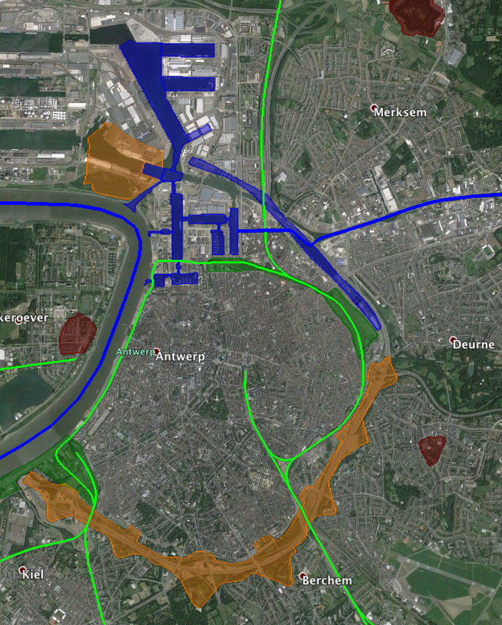
On the map, military fortifications that were active in 1914 are shown in red, military inundations in purple, and large recently decommissioned (in 1914) military fortifications are shows in orange. Navigable waterways, be they rivers, canalised rivers, canals, or maritime canals, are shown in blue. Docks which existed in 1914 are shown by blue overlays, and any docks not overlaid did not exist in 1914. Railway lines that were active in 1914 are shown in green, as are important railway stations. Large railway yards are shown as green overlays.
There are details available on all the shown items. For waterways and railways, click on the green or blue line to see the descriptions, for military fortifications, railway stations, locks, and docks, click on the icons.
For the best experience I recommend disabling all the standard layers except for Borders and Labels. The roads and photos in particularly are very distracting, so I definitely recommend turning those off.
Below are some links to various tellings of the story of the siege of Antwerp:
- The Wikipedia page describing the siege
- A short description of the siege on firstworldwar.com
- Arthur Conan Doyle’s description of the siege
- A description of the siege on metalfloss.com
The Brialmont City Walls
As described in detail in my recent post on Antwerp as Belgium’s national redoubt, in the late 1850s it was decided that the medieval walls of Antwerp needed to be replaced with new walls further out. The old walls were no longer up to snuff militarily, and the city needed room to expand. The new walls were built between 1860 and 1864. They were called walls, but if you’re imagining some stones pilled on top of each other in a line, think again, and think much much bigger. The walls consisted of two re-enforced earthen banks separated by a moat, with large castle-like fortified gates to allow people, traffic, and trains in and out of the city.
At their height, these walls surrounded the city on three sides, with the river Sheldt on the fourth side. There was also a large citadel built at the northern end of the wall, protecting the older docks close the the centre of the city.
In 1906 the walls were decommissioned militarily, and the northern citadel followed in 1910. Most of these fortifications remained in the landscape for decades after decommissioning, but the northern section of the wall vanished almost immediately. It was in restricting the growth of the port, so it was demolished almost immediately to make room for the new Albert Dock and the three new harbour docks which radiate from it. The Albert dock and the first new harbour dock opened in 1907, and the second and third new harbour docks followed in 1914.
In the screenshot below you can see the extend of the walls as they were in 1914, you can see that a section is missing to the north of the city from the citadel around to Deurne, and that the docks have extended out beyond where the wall had been until 1906:
The rest of the walls and the northern citadel remained largely intact in the landscape for many decades. The 1943 1:100,000 scale Ordnance Survey map still shows them clearly:
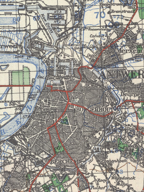
Click for Full Map (from McMaster University Digital Archive)
In 1963 that all changed when the walls were demolished to make way for an new road, the Ring of Antwerp, or R1 motorway.
The Port of Antwerp
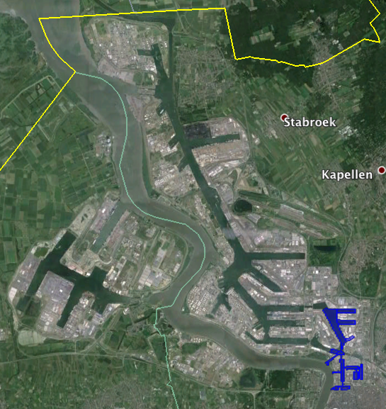
The physically biggest change since 1914 has to be the dramatic expansion of the port of Antwerp. As we’ve already seen the port began to expand rapidly the moment the walls were decommissioned, and that expansion accelerated in the decades that followed. The screenshot below really puts that growth into perspective. Highlighted in blue is the port as it existed in 1914:
Vanished Villages
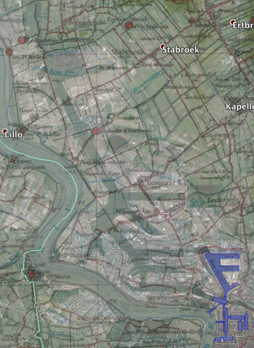
When you see the scale of the harbour’s expansion in the screenshot above, you probably find yourself wondering whether all that land was really empty in 1914? Compared to the city, sure, it was all polder land, so sparsely populated and used for agriculture. But, there is a world of difference between somewhere that is sparsely populated, and unpopulated! There were a significant number of polder villages compulsory purchased and demolished to make way for the port. The most significant of these vanished villages were Oosterweel, Wilmarsdonk, Oorderen, and Lillo. While these places have gone, their names have not, and if you look carefully you’ll spot them in the names of roads and other infrastructure in and around the port.
You can really explore this vanished landscape on the 1916 1:100,000 scale Ordnance Survey map of Antwerp, which you can view and download via McMaster University’s digital archive. You can get some sense of the scale of these compulsory purchases from the overlay of the map linked above over todays Google Earth imagery shown below:
Changes along the Nete
As you read the descriptions of the siege you’ll read about how the Germans attacked along the section of the defences between Walem and Lier. That entire area is dominated by the river Nete, and right in the middle of that front lines you’ll find the village of Duffel, which happens to be where I was born.
The river Nete formed an important navigation in 1914, and it continues to do so today. However, todays navigation is markedly different from the one that existed one hundred years ago.
In 1914 the river connected the Scheldt to the south south of Antwerp (via the Rupel) with the Kempische Vaart, a pre-cursor to the later Albert Canal which was built between the world wars. This allowed traffic from the south to connect with the industrial region around Liège and with Germany without having to go through Antwerp. The river’s course was a lot more meandering in 1914, and boats had to follow the main river from the Rupel into the town of Lier, where they would transfer to the canalised river Kleine Nete, which was very narrow and winding, and connect with the canal in Grobbendonk.
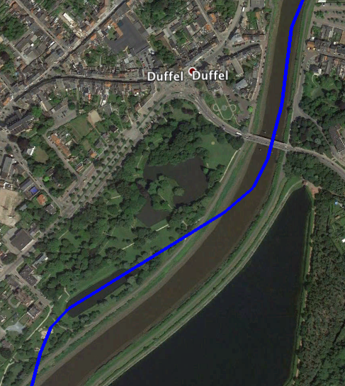
Today, the Nete has been straightened between the Rupel and a new set of locks to the north of Duffel village. Here, boats now leave the river, and join a large new canal, the Netekanaal, which runs around Lier, and then approximately follows the course of the Kleine Nete until it meets the Albert Canal near Viersel. You can still see a small remnant of the original alignment of the river in the town park in Duffel. What looks like just another long narrow pond is actually and small cut off section of river:
So, the Nete navigation has been straightened and enhanced with a new canal, but there were even bigger changes in the area. Some time after the second world war, presumably in conjunction with the building of the Netekanaal, massive water reservoirs were built alongside the canal and the river for a distance of over 7km with Duffel approximately at the centre of it all.
While the Nete was definitely a significant geographic barrier that would have hindered the Germans back in 1914, it was not nearly as dramatic a barrier as it looks today.
Crossing the Scheldt
Today, crossing the river Scheldt is easy. There’s a pedestrian tunnel in the centre of the city, the Kennedytunnel to the south of the city allows cars and trains to pass from one bank to the other, and the Liefkenshoektunnel allows cars pass under the river to the north of the city. Unusually, there is not a single bridge over the river in Antwerp, at least not yet.
In 1914 there were also no permanent bridges, and there were no tunnels. Two pontoon bridges were built across the river during the siege, but ordinarily the only way across the river was by ferry.
This led to a rather strange state of affairs – until 1933, there was a major railway terminus in the city of Antwerp that did not have an inch or railway track in it! The station in question was Antwerpen-Waas, and it was the terminus of the railway line between Antwerp and Ghent. Ghent is to the west of the Antwerp (and hence to the west of the river Scheldt) and the terminus was in the heart of the city, on the east bank of the river Scheldt. There was no bridge, and no tunnel, so passengers would be ferried across the river from the terminus to a small station on the left bank (Vlaams-Hooft) where they would finally board their train. In 1933 the pedestrian tunnel under the river opened, and its two ends were very close to the two railway stations in question. It was decided to close Antwerpen-Waas, and re-develop Vlaams-Hooft into a true Terminus station, named Antwerpen-West, or Antwerpen-Linkeroever. Trains continued to arrive on the left bank of the river until 1970, when the Kennedy Tunnel opened, and the line to Ghent was re-aligned through the tunnel to terminate in Antwerp’s largest station, Antwerpen-Centraal.
During the siege the lack of bridges or tunnels was a significant obstacle to be overcome. As the outer ring of forts fell, and the inner ring teetered, getting as many troops as possible across the river to safety so they could fight another day became a top priority. Had there been bridges that would have been a much simpler task. The temporary pontoon bridges helped, but you couldn’t run trains across them.
It’s because of the lack of bridges in Antwerp that the small village of Temse briefly became important to the Belgian war effort. That little village contained the nearest railway bridge across the Scheldt to Antwerp, and the Germans were closing in on it fast. At one point the Belgians ran trains at night with no lights on form Antwerp south towards the Germans before turning west and crossing the river in Temse. Despite the fact that the trains had come within just a few miles of the German lines, they were not spotted. This meant two things, firstly, at that the trains, and all on board, made it across the river safely, and secondly, that the Germans remained unaware that Antwerp was being evacuated.
On the other side of the river there were two parallel railway lines running west to safety – the mainline between Antwerp and Oostende (via Ghent), and a route that skirted the Dutch border via Sint-Gillis-Waas, Moerbeke-Waas, Zelzate, Eeklo and Maldegem to Brugge. There were a lot of soldiers and equipment evacuated from Antwerp across these lines.
The Development of the Left Bank
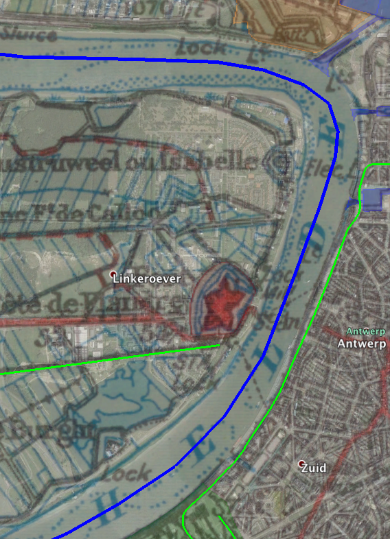
In 1914 there was almost nothing on the left bank of the river, the city was even more asymmetric than it is today. All there was on the left bank was a fort, Fort Vlaams Hooft, a small railway station, and a few houses. All the developments you see on that bank today date to after the second world war. The screenshot below shows the 1916 1:100,000 scale Ordnance Survey map of Antwerp overlaid over the modern Google Earth imagery:
The Decline of the Railways
Belgium today is rightly known for having a good rail network, but what remains today is actually just a fraction of what existed in 1914. Below is a screenshot of a similar area of Belgium as covered in KMZ file, but from a different project I’m working on, where current railway lines are shown in navy blue, and former lines are shows in green or yellow. Just about every green and yellow line on that map was operational in 1914, and with a few exceptions, so were the majority of the blues!
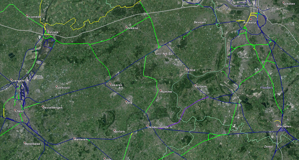
It’s not fair to imply that there has been no growth and only closures though. There have been a lot of new line built around the expanding port in Antwerp, and Belgium has built four new high speed lines in the last two decades, including one between Antwerp and Amsterdam which runs through the area covered in the screenshot above.
The Growth of the Canals
Having grown up in Ireland, the narrative I’ve come to expect when it comes to canals is that railways killed them, and roads killed the railways. What really struck me during this project is how differently things played out in Belgium. There are canals and navigations shown in the KMZ that are not in use today, but, the reason is not that they became unnecessary, but that they became too small, and were replaced with new canals that are bigger, straighter, and with fewer locks! The small and windy Kleine Nete has been replaced with the modern Netekanaal, the Dender has been re-routed around Dendermonde to allow it be widened, the maritime canal between Ghent and Terneuzen has been widened and straightened numerous times since 1914, and re-aligned around the town of Zelzate. The river Scheldt has been re-routed around Ghent, the maritime canal from the river Sheldt to Brussels has been widened and re-routed to avoid the river Rupel completely. The much wider and straighter Albert Canal has replaced the old winding canals between Antwerp and Liège. The canal from Ghent to Brugge has been widened and re-aligned to meet a whole new ring canal around Ghent that connects the Sheldt, the canal to Brugge, and the maritime canal to Terneuzen together, while letting large ships avoid Ghent. The navigable river Leie is now only used for pleasure boats, with commercial traffic routing around it via the ring canal and the widened Schipdonk Canal.
I also discovered a very similar story of dramatic canal development when mapping Mons as it was in 1914 a few weeks ago.
On the whole, inland waterways in Belgium have been growing not shrinking in the last century.
One pseudo-expcetion to this overall trend is the area that historically formed the headwaters of the river Durme. There is no more commercial traffic on the river, or on the canals that merge with it north of Lokeren. But, with the exception of the Zuidlede which can only be navigated by kayak these days, the vast majority of the waterways remain open, though only for pleasure boats.
Final Thoughts
As you read about Belgium during the first world war, you can perhaps sum up the changes like this: all the towns were smaller, the canals narrower, the roads smaller, and the railways lines more plentiful and must more important. Today, the motorways are the arteries that transport Belgians en-mass, but in 1914 it was the railways. Today, armies get around by air, but in 1914 you moved armies and their equipment primarily by rail.
Hi Bart,
I thoroughly enjoyed your recount of Belgian history in the two blog posts about Antwerp.
Also enjoy (so to speak) the ‘Taming The Terminal’.
Keep up the good work–and thanks.
Lou
Bart,
A very helpful blog on the siege of Antwerp; very interesting and well written.
I live in the Chicago area, where I am curating a grandfather’s collection of WWI photos, from his transportation unit in France and Belgium 1918-1919. Among the images, there are four aerial photos in a series showing a large port with ships. I am trying to identify this city. Looks like Antwerp, but there are two bridges (you said none, except the pontoons). And there are nearby hills, and I don’t remember any hills around Antwerp with a funicular.
Would you be so kind to assist me, by sending your email to me, so that I may send you these images for identification? thanks, don