The Author – Bart Busschots
Creative Commons
Unless otherwise stated, the content on this site is licensed under Creative Commons Attribution, Noncommercial, No Derivative Works 3.0 License


Oct
1
WW1 – Antwerp in 1914
Filed Under History & Geography on October 1, 2014 | 2 Comments

“Zeppelin bombing Antwerpen” by Ad Meskens – Own work. Licensed under Public domain via Wikimedia Commons.
One hundred years ago today, the siege of Antwerp was underway. It started on the 29th of September 1914, and the city did not capitulate until the 10th of October. Rather than re-tell the story of the siege, which you can read in so many places, I thought I’d share a Google Earth map I’ve spent the last six weeks creating showing the core infrastructure of the Antwerp area as it was in 1914. When reading about large-scale historical events, I like to use Google Earth to follow along with what I’m reading and get a sense of the local geography. The thing is, if you do that with the siege of Antwerp you may find it confusing to follow along because there have been some very significant changes in and around the city in the last 100 years.
In this post I’m going to detail some of the very big changes, but really, for the best experience, you want to download the KMZ file and explore it at your leisure in Google Earth. I’ve also included a substantial area to the west of the city in the map, as far as Ghent in fact, because this is the route along which the Belgian army successfully withdrew from the city as the siege neared its end.
The KMZ File
The KMZ file is broken into two primary sub-folders, one for outlines, and one for labels. The reason for this is that having the labels displayed while zoomed out makes the map too cluttered to get a good overview, so you can check both on or off independently.
On the map, military fortifications that were active in 1914 are shown in red, military inundations in purple, and large recently decommissioned (in 1914) military fortifications are shows in orange. Navigable waterways, be they rivers, canalised rivers, canals, or maritime canals, are shown in blue. Docks which existed in 1914 are shown by blue overlays, and any docks not overlaid did not exist in 1914. Railway lines that were active in 1914 are shown in green, as are important railway stations. Large railway yards are shown as green overlays.
There are details available on all the shown items. For waterways and railways, click on the green or blue line to see the descriptions, for military fortifications, railway stations, locks, and docks, click on the icons.
For the best experience I recommend disabling all the standard layers except for Borders and Labels. The roads and photos in particularly are very distracting, so I definitely recommend turning those off.
Below are some links to various tellings of the story of the siege of Antwerp:
- The Wikipedia page describing the siege
- A short description of the siege on firstworldwar.com
- Arthur Conan Doyle’s description of the siege
- A description of the siege on metalfloss.com
Sep
14
Antwerp – Belgium’s National Redoubt
Filed Under History & Geography on September 14, 2014 | 3 Comments
 Note: myself and Allison Sheridan had a good discussion around this post on episode 488 of the NosillaCast podcast (starting at 51:34).
Between 1851 and the end of the first world war, the city of Antwerp was Belgium’s so-called National Redoubt. It was decided that it would not be feasible to defend all of Belgium, so, the defence should instead be focused on holding a defensible part of the country until help could arrive from one of the powers guaranteeing Belgian neutrality. The city chosen for this purpose was Antwerp.
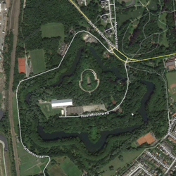
The fortifications built around Antwerp were impressive, in scale and design, both from a military and architectural point of view. They are without a shadow of a doubt archeological treasures, especially the late 19th century structures designed by the acclaimed fortification designer General Brialmont. While the later works were all more advanced militarily, they were never as architecturally beautiful as the late-19th century Brialmont forts.
Ultimately, the National Redoubt would never prove a resounding military success, but that doesn’t take away from it’s cultural, architectural, or historic importance. The redoubt had a big impact on the nation as a whole, and much more so on the province of Antwerp. The engineering work was on a scale comparable to that of building a railway network, and while much of that work is, by design, not easily visible at ground level, it’s immediately obvious from the air if you know where to look.