The Author – Bart Busschots
Creative Commons
Unless otherwise stated, the content on this site is licensed under Creative Commons Attribution, Noncommercial, No Derivative Works 3.0 License


Jul
17
Google Earth – Illuminating our History
Filed Under History & Geography on July 17, 2008 at 9:35 pm
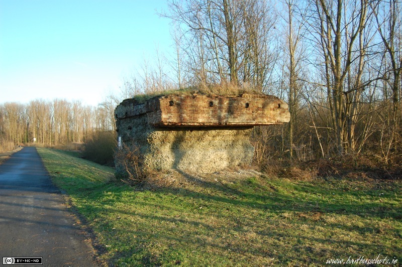 I’ve loved Google Earth since I first used it, but today I had a real “wow” moment with it. Last Christmas my interest in trains was re-kindled when I took some time to do something I hadn’t done in years, shoot some photographs in and around my native village, Duffel. I got some lovely shots of trains but also came across a very curious artefact. A lump of brick, cement and steel with a sign on it. The sign indicated that this strange lump was all that was left of a railway bridge. I looked around, there was nothing even remotely resembling a railway line, or indeed even the track bed of one. It turns out that most of the track bed was ripped up, and used to build the near-by E19 motorway, which runs between Brussels and Antwerp.
[tags]railway, local history, Google, Google Earth[/tags]
I didn’t think much more about this until I was reading a website about Belgian railway lines that mentioned the now abandoned Line 25A. Why did that catch my eye? Because I know that the line that now runs through Duffel, along which I was shooting trains, is Line 25. As I read the place names I started to recognise them. Hang on, this is very close to home! I fired up Google Earth, and went to zoom in to see the line of the place names to get a rough idea of the route of the track. I didn’t need to zoom in far. The bed of the track, which was completely invisible at ground level, jumped out at me on Google Earth before the place names had even loaded and displayed!
The amount of history that’s visible, plain-as-day, on just the one screen-shot below is astounding. Not only can you clearly see the path of the decades gone Line 25A, you can also see three local fortifications used in the first and second world wars. In the flat Belgian landscapes these forts are very hard to see from the ground, but from Google Earth’s perspective they jump right out at you with their distinctively shaped motes. Can you spot the three forts and Line 25A?
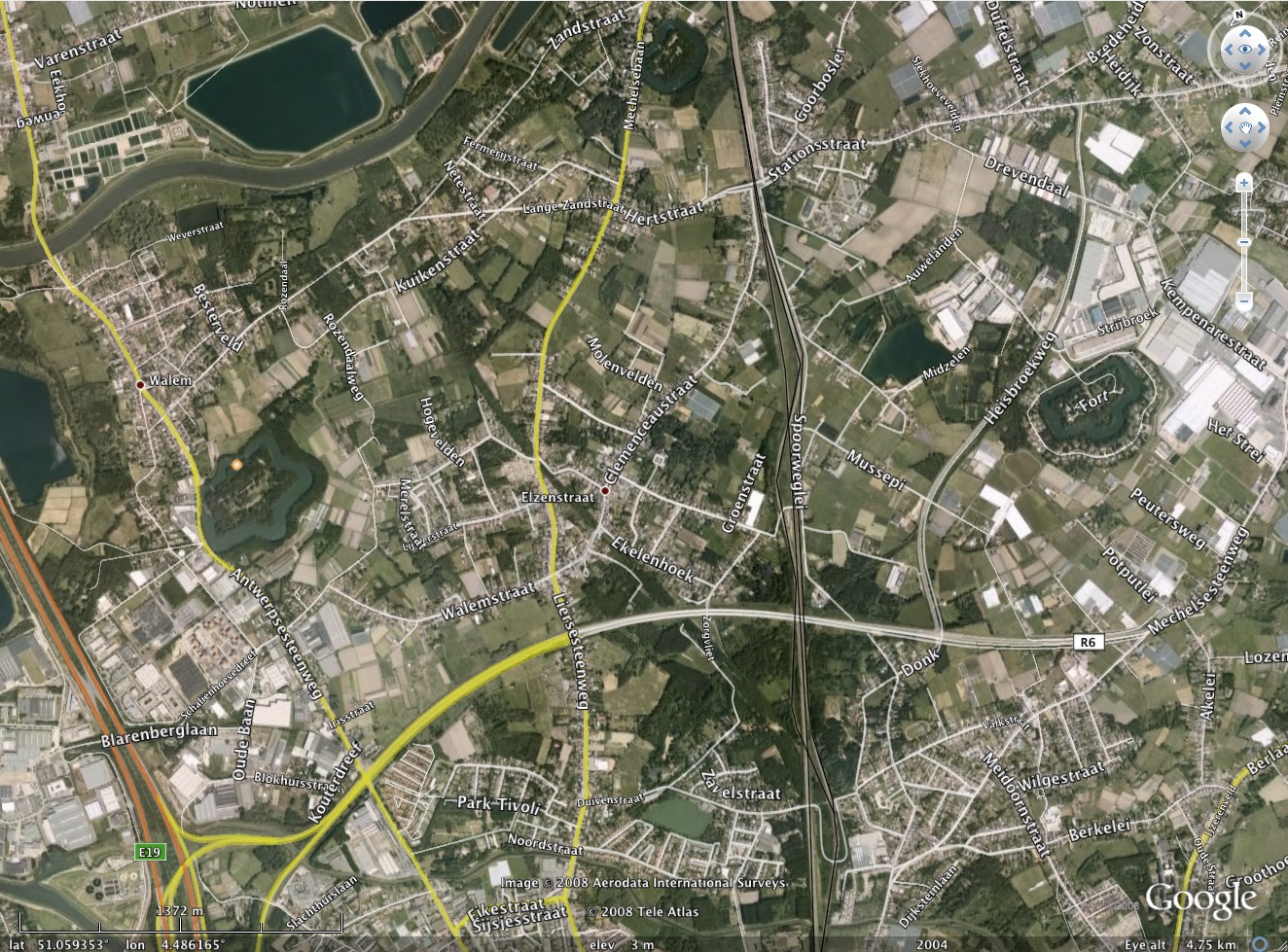
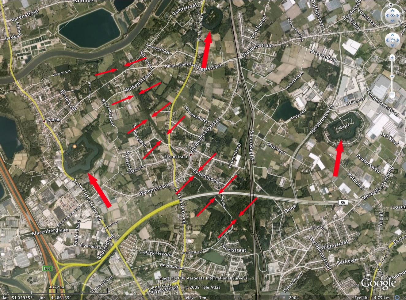
If you need a hand here’s a version with the features marked in. BTW, the spot where the path of Line 25A meets the river near the top of the shot, is where I stopped to look at the tiny remnant of bridge. Also, if you look near the bottom left of the frame, you can see the E19, where a lot of the material from the track bed of line 25A was re-used.
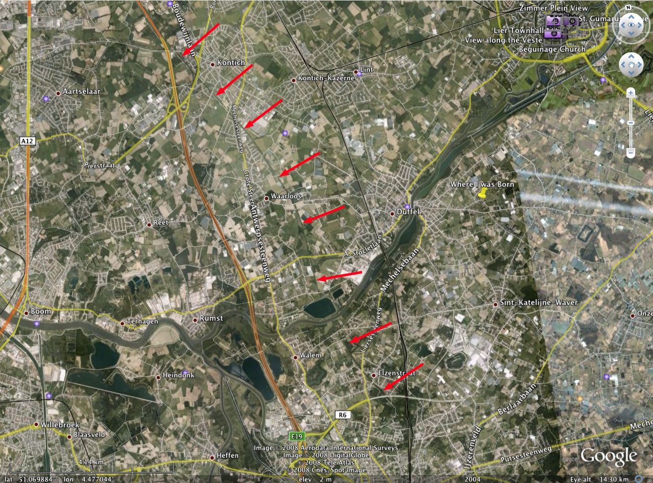
You might notice that near the top of the shot the path of Line 25A gets a little lost among new developments. A view zoomed a little further out shows that you can continue to follow it north of the river Nete too. In fact, you can follow it all the way to Kontich, where the E19 joins the remnant of Line 25A and follows it’s path into Antwerp. The screen-shot below shows the full track of Line 25A, from where it leaves Line 25, to where the E19 motorway takes over it’s bedding, just outside Kontich.
Finally, the reason I found the information about Line 25A was because I was looking for a definition of the abbreviations HLE, HLD, and HLR. You see these all over the place on websites related to Belgian trains and railways, but always used without explanation. Today I discovered they’re not actually abbreviations at all, they’re codes! In fact, they date back to the days of Morse Code! This is yet another example of how history can live on. Here’s the full list of related codes I found:
HK– trainHKV– passenger train (“voyageurs”)HKM– freight train (“marchandises”)HL– locomotiveHLD– diesel line locomotiveHLE– electric locomotiveHLR– diesel shunterHLZ– diesel locomotive
If you’re into this kind of thing you’ll find a full list of the old Morse Codes relating to the Belgian railway system here.
[…] At the time this excited me enough to blog about it, so rather than repeating myself, you can read my original post for more details and some pictures and […]
Hi there Bart,
It’s very interesting isn’t it, following the old rail lines from the air–I like tipping the angle down to where you’re skimming along above the grade – very cool – I first found the power of google earth in investigating for any remains of an old interurban rail line which had once existed around the turn of the century in my old home town of Cleveland Hts Ohio and the eastern lands of North East Ohio; I had always heard that the old train tracks(which you could see here and there) were part of an old line which stretched for miles out into the country…I was amazed at how much of the line could be traced across the landscape even after 80 or more years since the trains had run…it led me to finding a website dedicated to the old train line.. http://www.trainweb.org/ceihsm/construction.html
anyway–thanks for your interesting blog…it’s kind of like finding old Roman remains around…ancient concrete bits and pieces…
Frank
Thanks for your comment Frank – I hadn’t thought about setting the angle like that, definitely gonna give that a go!
Bart.
[…] been working on a project to map Belgium’s railway history for about three years now (first post, first update, latest update). My map is coming on nicely, with just about all the main lines and […]